One of the more exciting areas of growth in the data space is the construction and leveraging of digital twins. A digital twin is a representation of something in the real world, like an object, building, factory, city, or process. The point is to show some known state so that better insights, experiences, and decisions can be made. The representation can be captured with all sorts of digital data, such as 3D models, text, and sounds.
The known state can be many things. Here are some examples of the “known state” and how it can support different types of decisions. From countries to cities to individual objects, the value of using a digital model to analyze, plan, share, and gain understanding is immeasurable. It gives organizations opportunities to reduce errors, save money, improve communication, create enhanced experiences, and increase productivity.

Digital twins are relevant to many industries and their uses are limitless. Here are just some of the ways that digital twins are used today.
Governments - From planning new spaces and projects to maintaining existing infrastructure, digital twins increase understanding and reduce the effort required to understand. For example, with rising oceans and changing weather patterns, digital twins enable governments everywhere to plan and prepare for the future. An accurate digital twin model is critical for increased understanding of new and existing spaces and infrastructure.
Construction Companies - For many projects today, digital twins or ‘digital models’ enable construction companies to share what the final result will be in a full 3D experiential model in context. This ensures that there are fewer surprises when a project is completed as people can see what it looks like and how it impacts the existing environment.
Building Maintenance - Maintaining a building is a much cost over the lifetime of the building than the initial construction. A digital twin of a building can greatly reduce maintenance costs by making it easy for maintenance staff to visualize building infrastructure inside walls. Modern building devices are often equipped with wireless connections so that they can relay their status in real-time. Placing these devices in context in a digital twin makes it much easier for staff to understand where a device that needs servicing is located.
Real Estate - In the past, to view a property, you had to physically go to open houses. Today, you are able to “visit” the location and experience it through a screen. Indeed, it is often the case that you can explore properties digitally, even before they are built. Digital twins make this all possible.
Retail - With the move towards online shopping, we are seeing organizations creating digital twins of products, like furniture. You can place these objects in your real-world space using augmented reality to see how they fit and will work. Ikea is a great example of a company that offers this service.
Tourism - Go on self-guided tours of places, past or present. Imagine touring an old castle but being able to use a digital twin to see what it looked like when it was in its prime. The potential to increase understanding and enjoyment of historical sites is immense.
Insurance - Having a digital twin of a city, building, or infrastructure and then being able to combine it with other data such as flood plains, historic weather and disaster events offers a whole new perspective and level of insight for insurance companies.
Disaster Recovery - From being able to locate and visualize infrastructure or people to representing air quality or other hazards that are part of the environment, digital twins can play a huge role in situational awareness.
Airports - Airports are complex facilities with lots of activity. Operational efficiency and a smooth customer experience are paramount to a good airport. A digital twin of an airport can make a big difference in managing all the infrastructure assets of an airport.
Rethinking RIPA Data Compliance
How Fremont uses FME to turn complex RIPA reporting into an automated, auditable pipeline across GIS and public safety operations.

Many more - As you can see, the use cases for a digital twin are endless. Anywhere you want to gain an understanding of a physical space or object, a digital twin will reduce the effort required to understand it.
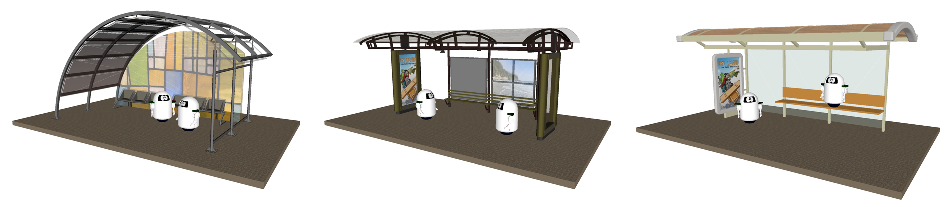
A webinar hosted by Safe Software “Exploring Outdoor Infrastructure with AR” demonstrates how a community can decide on a new bus shelter design by opening up the various models (above) in the FME AR app in the actual city space where it will be built.
On a city scale, being able to see a new building in context and how it impacts the citizens and the viewscape helps citizens understand the impact of any new construction project. Modelling and simulations can also be done to see how the new project impacts the environment. Some of the important things to model include the impacts of new shadows, loss of important views, and changes in wind velocities in a downtown core. A new large-scale building project can impact many aspects of a city, and being able to see it in context is invaluable.
Historical Date: We have also seen digital twins constructed of historical buildings or settlements. Similar to tourism, often these can be put in the original location to help understand the settlement better and how people lived. Here is a digital twin of a WWII internment camp.
The model takes our understanding to a new level. Other uses are to show how cities and civilization have changed over the years.
Current Date: Digital twins of the current time are useful for maintaining city infrastructure and can help workers identify and determine the state of city infrastructure.
Here is an example of how Japan is building digital twins of cities and a on how to view it on a browser.
The point is that once the model is constructed it becomes a valuable resource for the city. The model gives insights and the ability to view, explore, and understand their city in ways that before were not possible.
Inside Burnaby's GIS Backbone
A deep dive into FME, NG9-1-1 readiness and the data architecture behind modern municipal GIS operations.
Through powerful modelling and simulation, this technology helps organizations analyze and predict outcomes, saving them time, money, and even improving safety.
Digital Twins and Augmented Reality
Digital twins and augmented reality are technologies that support each other. While a digital twin is the collection of interconnected data that represent objects, augmented reality enables us to visualize it in a natural and fully immersive way. One is not dependent on the other, but when combined, the value of both is enhanced. Digital twins can be visualized on large monitors or other 2D screens, but it is when you bring these two technologies together that the “magic” happens, as now you are able to experience the Digital twin as it is combined with all the information of “reality”.
Many of the examples we have hereafter are indeed digital twin data that is shared and experienced via augmented reality.
Getting Started with Digital Twins
As you can see, more organizations than ever are creating digital twins. We’ve seen applications in engineering, architecture, facilities management, urban planning, utilities, transportation, airports, manufacturing, medicine, and more. TIME wrote a great article on the topic that highlights various industries—for example, a German BMW factory has an exact 3D replica in which every surface and piece of machinery is represented. This digital twin can be accessed by screen or virtual reality headset and allows them to optimize the assembly line, saving time and resources.
A digital twin of a city can help workers track the state of different assets, such as the rust on this electrical box (top left) or the uneven sidewalk (bottom left).
Example: Analyzing a Crosswalk in Augmented Reality
Taming Spatial Data Complexity
Unpack the integration challenges of fragmented location data and how new approaches turn spatial chaos into usable intelligence.
Below is a video demonstrating a simple digital twin created using FME. When we consider crosswalk data, simple ways to represent the object include placing a line on a map or rendering a generic 3D model. But to make it a digital twin, we can take a LiDAR scan of it, blend that with photos, add a sensor that tracks pedestrian traffic, and enrich it with metadata from a city database. Once the digital twin is created, a field worker could stand on the real crosswalk while viewing its digital twin through an augmented reality app on their phone or tablet, overlaying the digital version against the real world to see how it changed after a snowstorm. It could also be brought into a GIS so a specialist could assess the situation and make decisions.
The video demonstrates using the FME AR app to choose an AR model and view it against the real crosswalk.
Are you ready to embrace this growing trend and create a digital twin for your organization?
Step-by-Step: How to Create a Digital Twin
Creating a digital twin requires various types of data. The more datasets that are integrated, the better, more realistic, and more compelling the digital twin will be. Common data types that are key to creating valuable digital twin models include vector, raster, LiDAR, and 3D, among others.
Step 1. Assemble and collect data
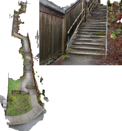
The first step is to consolidate data from multiple sources. Consider floor plans, blueprints, images, video, metadata, and sensor data. Thankfully, gathering all of this doesn’t have to be expensive or complicated. A lot of the required data will already exist in CAD, BIM, images, databases, and other formats. For data that doesn’t exist yet, there are many options for acquiring it, including sensors, photos, and videos. Mobile devices like newer iPhones have built-in LiDAR scanners that take impressively accurate scans. The below image shows the quality and resolution we can get from an iPhone 13. This is not a photo—it’s a textured 3D mesh!
This mesh was created using an iPhone’s LiDAR scanner, which is widely accessible and demonstrates that you don’t need anything fancy to create a digital twin.
Step 2. Integrate and preprocess the data
Digital Twins Reshaping Data
How virtual replicas plus spatial integration turn raw sensor feeds into a strategic asset for planning, operations and customer service.
Once all of the data is identified and created, a data integration platform like FME can be used to easily convert, blend, and process it. For example, in the below image, our expert Dmitri Bagh has used FME to turn an iPhone LiDAR scan into a reality mesh that can then be used for a city project. The georeferenced LAS point cloud can also be used for analysis.
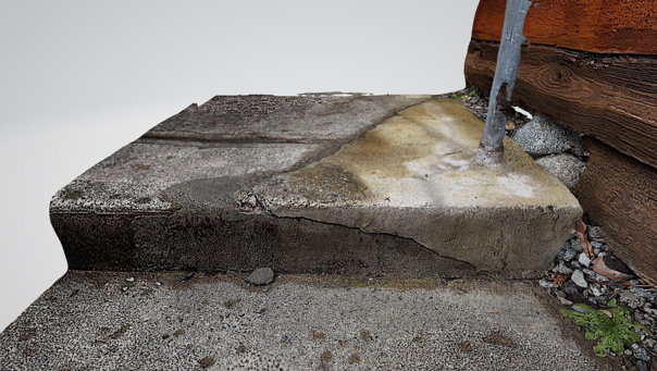
This reality mesh was created by generating a point cloud using an iPhone’s LiDAR scanner. Using this data, a step that needs fixing can be identified.
This is the part where data can be validated, geometries repaired, and formats converted. For example, 2D data can be extruded and a raster texture added, or a complex BIM model could be simplified.
Creating a perfect twin of reality is complex, so it’s often helpful to simplify or adapt the data for the purpose of the project. This is where you’ll want to refine the dataset to include only essential information so the digital twin isn’t excessively large. For situations like indoor mapping, the twin might even be better rendered in 2D than 3D. It really depends on your goal!
Step 3. Render the geometry
After the data is integrated and preprocessed in FME, the result can be rendered in a number of ways:
- as a scene in a web browser (e.g. using three.js, Cesium, or I3S)
- in augmented reality or virtual reality
- displayed in whatever system an organization requires
Digital twin technology is growing and many specialized options are available. For example, Amazon has released an AWS IoT TwinMaker service, and Autodesk has released Tandem.
The below video is an example of using an iPhone’s LiDAR scanner and FME to create a digital twin of a roundabout, which can then be viewed in FME AR. This enables analysis for decision-making.
[Webinar] See how Amsterdam Airport Schiphol created a digital twin of the airport: Planes, Trains and Automobiles - Handling Infrastructure Assets with FME
Step 4. Keep the data up to date with automation
Part of what makes a digital twin a “twin” is that it’s a live feed of the physical object. As part of a larger IoT solution, your digital twin should involve sensors and automation to keep it synchronized with the real world.
The degree to which it is “live” depends on the scenario—for example, an assembly line is going to need a lot more sensors and real-time automation than a digital twin of the buildings in a city. In some situations, it might be enough to survey an object once in a while and update the twin.
In the below gif, we are tracking how crosswalk paint gets worn down by measuring the amount of white that disappears between scans. This is an example of a simple digital twin that seldom needs updating, so running a data integration workflow on demand every few weeks is sufficient.
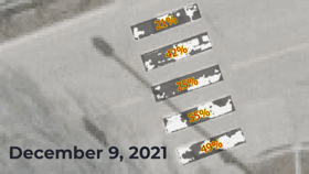
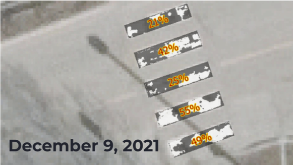
Comparing the amount of white paint in a crosswalk scan month-to-month.
Keeping a digital twin up to date as new data arrives can be handled automatically using FME Server Automations. It can be updated on a schedule (e.g. every hour, day, month) or in response to an external event, like a database being updated. If you have high-velocity data from sensors, you can then leverage FME Server Stream processing.
Now you’re ready to use your digital twin! Set up workflows to automatically respond to alerts, use them to make data-driven decisions, generate predictions, and more. You can also continue to process the data by sending it to business intelligence software or other systems for further analysis.
Creating a digital twin is a more accessible goal than ever—LiDAR scanners and other sensors are widely available, along with data integration workflows and the power of automation.
If you are as interested and excited as the team at Safe Software about the possibilities that Digital Twins and AR have to offer, make sure to follow Dmitri Bagh, Safe’s Scenarios Specialist, to watch first-hand as he tests out AR with FME.

Comments ( 0 )